


by Susan Couso
Thousands of emigrants passed along the Nobles Trail into what was to become Lassen County. As they turned south onto the route of today’s Highway 395 and crested the rise, which is still called Viewland, they were amazed at the beautiful panorama ahead of them. This was what they had hoped for.
The trail turned westward towards California, and as the emigrant trains neared the site of today’s Susanville, they followed the pretty little river named for William Nobles’ wife, Susan.
The trains would camp where Memorial Park is situated and spread their livestock out to graze and refresh for the trek ahead.
The trains moved on up the trail, roughly where Nevada Street is now, and then turned to the north of the little bluff, up today’s North Pine Street, before turning to the west again.
They roughly followed the Susan River until they reached the perilous chasm which we call Devil’s Corral.
Here they turned farther north and followed an easier route, weaving back and forth along where Highway 44 currently runs. They worked their way through the wilderness, traversing present day Lassen National Park, and then on down into the lush valley below.
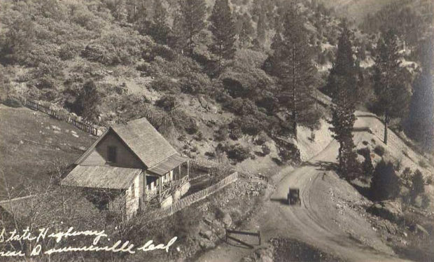
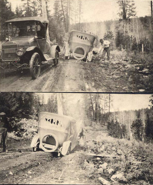
The Honey Lake Valley area grew in leaps and bounds and people still used the same path as those early emigrants did to reach the northern California valleys. It was a narrow, crooked, and sometimes steep trail.
As the valley grew more populated and traffic to and from the valley towns increased greatly, the road became a dangerous place. The oxen and horse-drawn conveyances were replaced with motorized vehicles, which were so much faster and larger. The curves and grades caused quite a challenge. Even today, Susanville’s North Pine Street is a bit of a threat to unwary drivers.
By the early 20th Century, it was evident that something needed to be done to make the highway to the west more passable.
Many attempts were made to get something done to improve the road conditions and small repairs and improvements were made. Still, it remained a rough ride with many treacherous and scary sections.
By 1928 the Red Bluff – Susanville State Highway was in full use. It was considered a scenic drive through the newly formed Lassen Volcanic Park, and an entry point to the recreational opportunities in the area. But it was also a vital link between Susanville and the many business ventures with the rest of California. The importance of this route was noted in 1909 when it became a state highway, connecting two county seats, Red Bluff and Susanville.
The new highway was a great improvement, but there was still the problem of those tight curves and steep grades, especially at the entrance to Susanville.
The work had included creating a new access to town by making a cut into the south side of the Inspiration Point Bluff and connecting near Quarry Street. This was a great idea which eliminated the sharp turns of North Pine Street, but it was still a narrow cut with a sharp turn at the Quarry Street connection.
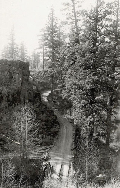
The one-half-mile section of new roadway between North Pine Street and Quarry Street contained three very sharp curves and an exceedingly narrow cut on the very steep grade which still causes problems today.
The new highway also had numerous issues at 5,400’ foot high Fredonyer Pass and the chasm known as Devil’s Corral. The steep narrow roadway was a headache for motorists and maintenance workers alike, especially in the winter snow.
By 1931, the dangerous aspects of the highway were again on the minds of local citizens. It was obvious that to make the curve into Susanville less dangerous, some houses would need to be removed.
The city worked to obtain a new right-of-way through established homes at the site. Those citizens who were going to lose their homes were Wright L. Spalding and Mrs. Lena Caughell, and others, including Hans P. Jensen, E. W. Short and George Scott owned unimproved property in the proposed right-of-way.
The owners demanded a total of $26,500 for their property, and the city just didn’t have the money. The state highway commission eventually agreed to pay $10,000 to help, and Short and Jensen, who only had vacant land agreed to a tentative property exchange to ease the situation.
The city faced the problem of either paying the landowners, filing condemnation suits, or simply abandoning the project altogether and leaving the city entrance as it was.
By July, negotiations and plans to redo the section of highway from Devil’s Corral to Susanville were going ‘full steam ahead’, and engineers worked frantically to find solutions to the many concerns about the dangers of the highway. They came up with a proposal.
The short perilous curves would be replaced with larger turns and the new entrance into Susanville would have the level lowered by eight feet to make a long sweeping grade.
Finally, by March 1932 the long negotiations with the property owners were finalized.
Wright Spalding got $9,500 and Lena Caughell received $3,500. George Scott sold his vacant lot to the city for $500. The state paid $12,500, which left only $1,000 for the city to come up with. It was a great deal for the city because they had excess property. Whole lots were purchased, so they could then sell the excess land that was not needed for the right-of-way itself.
All buildings had to be removed from the right-of-way before April 15, 1932, and Mayor E. P. Honsberger agreed to finish this task on time. This feat was accomplished, and work began immediately to finish the Red Bluff – Susanville Highway and secure a safe new 100’ wide entrance into Susanville. The entire project was to be completed in one year, with different contractors working on different sections of the highway.
W. C. Colley of Berkeley was awarded the contract to construct the road from Devil’s Corral into Susanville for $219,000. Colley promised to hire as much local labor as possible, a wonderful ‘plus’ since unemployment was at an all-time high as the Great Depression was in ‘full swing’. Everything was in place and agreed upon, and the work of rerouting and realigning the highway began.
By the spring of 1934 the final coating of crushed rock and oil was applied to the beautiful new Red Bluff – Susanville Highway. It had been many years in the making, but travelers could now enjoy 108 miles of the best road available.
As the work finished on the Red Bluff – Susanville section of the highway, crews immediately moved to the other end of town to begin work on the route to Reno.
If you are a fan of our weekly history stories you should join the Lassen County Historical Society! It’s a fun way to be a part of our county’s rich history. When you sign up, you’ll receive regular Historical Society newsletters with interesting stories and information. Membership is open to anyone with an interest in area history.
Through your membership you help preserve local history. You can download a membership application by clicking here.


