


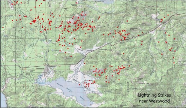
 Just as the Hog and Gold fires begin to wind down firefighters are having to deal with a round of lightning-sparked vegetation fires across the region. Lightning trackers recorded hundreds of lightning strikes Sunday afternoon, leaving a trail of small vegetation fires in their wake.
Here is current information on Lassen County’s two largest fires.
The Hog Fire
Containment continues to increase on the Hog Fire with Cal-Fire estimating that the 9,545 acre fire is now 60% contained.
Today firefighters will be working aggressively to establish and improve control lines.
A Red Flag Warning, due to a low pressure system moving in, will be in affect until tonight at 9:00p.m. The weather will be hotter and drier today and fire growth potential remains high.
A natural-source water supply has been established that does not affect the surrounding communities.
Damage inspection is complete there were a total of two structures destroyed.
Both SR-36 and SR- 44 are now open for through traffic, however, flames and smoke from the fire’s interior may be visible as you travel.
All evacuation orders have been lifted, as residents are allowed to return to their homes, please drive carefully as emergency personnel are still working throughout the fire area.
The Gold Fire
The 21,870 acre Gold Fire burning in northern Lassen County is now 55% contained and has destroyed 13 structures, damaging 5 others and still threatening 25.
There is no estimated time for full containment of the fire which is burning off of Highway 139 and County Rd. A-2, south of Adin.
As thunder cells continue to develop in the area and the potential for high winds, crew will focus on strengthening and building containment lines.
Over the next 48 hours the potential for Red Flag conditions in the fire area may exist.
The incident continues to burn in areas with private residences, ranches and commercial operations including agriculture, livestock and timber.
Evacuation Orders (Immediate threat to life. A lawful order to leave now, the area is closed to public access):
Zone B – Areas south of Ash Valley Rd., west of Spooner Rd., east of Hwy 139, and north of Termo Grasshopper Rd.
Zone G – Area north of Ash Valley Rd. to Rail Canyon north to the Modoc County line and west to Hwy 139.
Zone H-1 – Area north of Ash Valley Rd. at Knox Mountain north to the Modoc County Line, and west to Rail Canyon.
Evacuation Warnings (Potential threat to life and property. Those who require additional time to evacuate or have pets/livestock should leave now):
Zone C – Areas west of Hwy 139, south of Hayden Hill Rd., east of Anderson Ranch Rd/Dixie Valley Rd and north of Long Flat Road.
Zone D-1 – Ash Valley Rd at Williams Rd. south to Mallard Dr., west to Prairie Rd. south to Termo Grasshopper Rd., and west on Termo Grasshopper Rd. to Spooner


